


GPS/Hydrography Preserve a Shoreline
In October 1994, the town of Hilton Head Island, South Carolina, authorized funding for a detailed investigation of a chronic beach erosion problem along the northeast end of the island. This section of the island is occupied by the Port Royal Plantation, a private development. The crosion problem threatens numerous shorefront properties and a beach club that is central to the area's shorefront recreation.
Read Full Case Study
In October 1994, the town of Hilton Head Island, South Carolina, authorized funding for a detailed investigation of a chronic beach erosion problem along the northeast end of the island. This section of the island is occupied by the Port Royal Plantation, a private development. The crosion problem threatens numerous shorefront properties and a beach club that is central to the area's shorefront recreation.

Mapping Mission
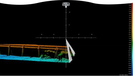
The wreck of U390 sunk on July 5, 1944 by HMS Tavy and HMS Wanderer using the hedgehog forward ring mortar. Only one member of the U-Boat survived. U-390 was a snorkel tted type VIIC boat and was on her third war patrol at the time of her loss. In the image the bow is to the top with the propellers and rudders clearly visible at the stern. The conning tower can just be made out to the right as is the port side ballast tank (the bulge on the central hull).
Read Full Case Study
The wreck of U390 sunk on July 5, 1944 by HMS Tavy and HMS Wanderer using the hedgehog forward ring mortar. Only one member of the U-Boat survived. U-390 was a snorkel tted type VIIC boat and was on her third war patrol at the time of her loss. In the image the bow is to the top with the propellers and rudders clearly visible at the stern. The conning tower can just be made out to the right as is the port side ballast tank (the bulge on the central hull).